Click MENU Icon to Close
Image: Landsat8/NASA
Tidewater Current
Feature
SEARCH
Click MENU Icon to Close
| Down to Earth Applications for Space Agency Research
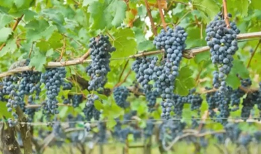
Posted 3 February 2016 by Carol Brighton Most folks associate NASA with space exploration. The International Space Station and missions to Mars readily come to mind. In addition to the study our solar system and galaxies far away, another very important mission of NASA is earth observation. Monitoring earth systems from the vantage of space provides critical weather, land use, and environmental data. With some data sets covering decades, important trends can be identified to inform land users and policy makers. The remotely sensed data sets are freely available and are being put to work to help humanity with many benefits felt locally. The wine industry is one of the fastest growing agricultural sectors in Virginia. The Commonwealth ranks fifth in the nation for wine production and sales of wine have increased 26 percent since 2010 reaching record highs in 2015. The industry also supports a thriving tourism economy with an estimated 1.6 million visits to wineries in 2014. Last year Bloomberg News counted Virginia among the world's next big wine regions and Wine Advocate rated 60 wines at 90 or above. But there's a problem: “Although Virginia wines are garnering global acclaim and sales continue to grow, the industry’s greatest challenge is to plant more vines to meet the increased product demand,” said Todd Haymore, Secretary of Agriculture and Forestry. Setting up a vineyard is expensive, costs run up to $16,000 an acre, in addition to the cost of purchasing the land. To encourage the continued growth of the industry, the State agriculture department and the Virginia Wine Board teamed up with NASA Langley scientists on a project aimed at putting more land into grape production. From satellite data, scientists at NASA mapped some 300 existing vineyards in the Commonwealth. “Grape growers will combine that location data with information about the soil, slope of the land, angle of the sun, frost dates and so on to make a determination about where to plant new vineyards," explained Haymore. According to Alexander Morgan, general manager at James River Winery, “to keep up with the demand, we are seeing many wineries in Virginia using juice from other wine grape-growing states like New York. This study will help us locate the best place to continue to plant and other places to start production for wine grapes in Virginia. It can be a real game changer for the entire industry in the state.”
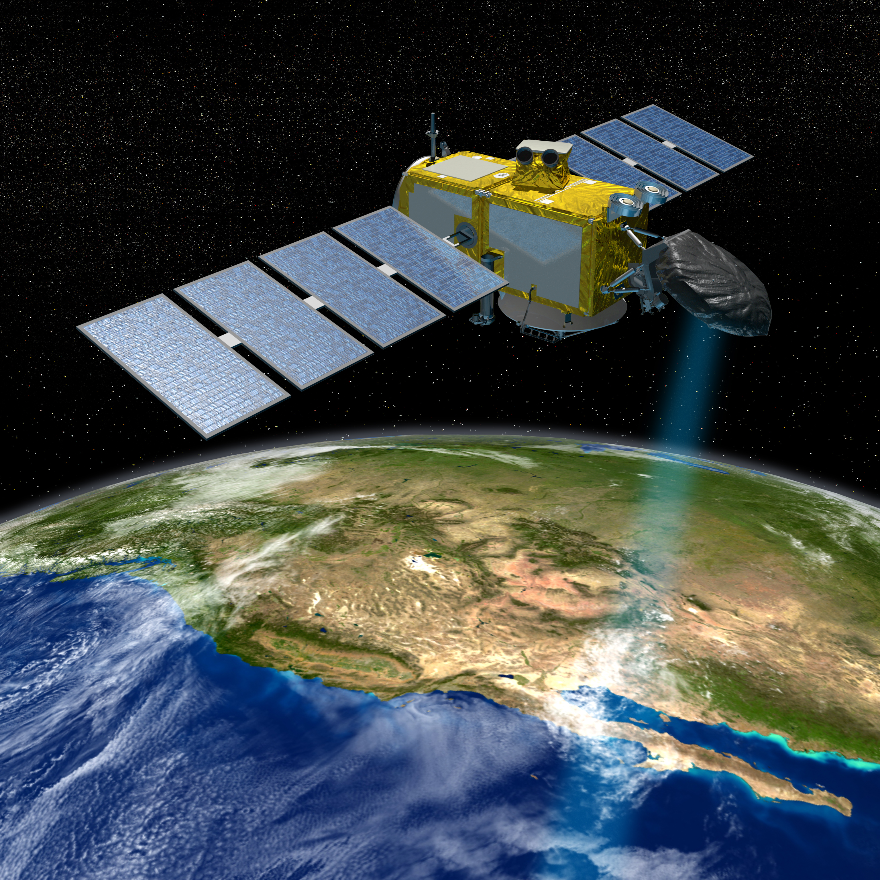
Observed trends, like the steady rise of global temperatures, have been flooding news outlets and fueling international debate. Based on independent data analysis, NASA & NOAA jointly announced on January 14 that 2015 was the hottest year on record, knocking 2014 out of the top spot by a wide margin. A phenomena closely associated with global warming is sea level rise. Satellite derived climate data will be vital to planners and policy makers around the world and in Coastal Virginia which has been identified as the second most vulnerable region to sea level rise in the nation. Already many low lying localities are suffering from the impacts of rising seas. With more tidal shoreline than any o f the lower 48 states, Virginia residents sit on the frontline of global climate change. Some 628,000 residents are thought to live on land elevations within 6.5 feet of sea level. The vast majority of these citizens reside in coastal cities. To monitor changes in sea level, the Jason-3 satellite was launched Jan 17 to continue a quarter century of satellite tracking data. The legacy mission is a joint project between NOAA, NASA and the French Space Agency CNES. “As human-caused global warming drives sea levels higher and higher, we are literally reshaping the surface of our planet,” said Josh Willis, NASA project scientist for Jason-3 at the Jet Propulsion Laboratory (JPL) in Pasadena, California. “These missions tell us how much and how fast.” In addition to sea level measurements, data from Jason-3 will be used to model and forecast waves, tides, currents and conditions during storms and environmental challenges such as oil spills and harmful algal blooms. Data for Coastal modeling crucial for marine mammal and coral reef research and forecasts of El Nino and La Nina events will also be generated.
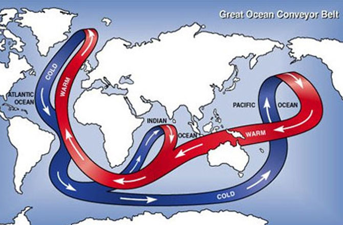
Another cause of local sea level rise is the slowing of the Gulf Stream. Now scientists can track currents from space by extrapolating data obtained from NASA's GRACE satellite. The flow of the Gulf Stream is regulated by an oceanic conveyor belt loop that recirculates heat and nutrients called the Atlantic Meridional Overturning Circulation (AMOC). As the system weakens, it slows down and water piles up along the mid-Atlantic. According to Michael Watkins, director of the Center for Space Research at the University of Texas at Austin, “We've wanted to observe this phenomenon with GRACE since we launched 13 years ago, but it took us this long to figure out how to squeeze the information out of the data stream." Tracking the flow of this current will not only help forecast local sea surface conditions, because of the AMOC's role in a global oceanic circulation, our understanding of its influence on climate will improve.
NASA Langley Developing 8 Microsatellite Network to Track Hurricanes On top of rising seas, hurricanes pose an additional threat to the region. And as the world warms, its been suggested that hurricanes will not only be stronger, they will track poleward, putting the mid-Atlantic in a precarious position. So, the good news is that a new satellite system being readied for deployment will improve hurricane forecasting. The "Cyclone Global Navigation Satellite System" (CYGNSS) is a pioneering microsatellite monitoring system from the Earth System Science Pathfinder program, run by the Langley Research Center in Hampton, Virginia. Comprised of a network of eight small satellites, the system will provide better global coverage than any one observation system could. Detailed measurements of ocean surface winds in and near the eye wall of tropical storms and hurricanes throughout their life cycle will be recorded. With this information, forecasters can better predict a storm's course and strength at landfall. The body of each satellite measures roughly 20-by-25-by-11 inches. With the solar panels deployed, each microsatellite will have a wingspan of 5.5 feet. Initial testing is scheduled for early this year with deployment planned prior to the 2017 hurricane season. More Info. It's rather fortuitous that NASA is gathering all this data. They'll need it. Many of the agency's assets are located in areas prone to suffer the impacts of storms and rising seas. Among them, the Mid Atlantic Orbital Spaceport on Wallops Island, Virginia which will be used to resupply the space station. Read more about rising seas and satellite imagery in these Tidewater Current posts: With the Support of Pharrell, Climate Action is a Hot Topic this Winter Climate Progress: Virginia, Maryland and Delaware Investigate Sea Level Rise Solutions The Rising Tide: Research and Planning Watching the Sea from the Stars: SkyTruth Fighting Fishy Activity in the Seafood Industry: Fleet Monitoring
|
|---|
Check the Archive for Previous Posts
All Rights Reserved: Disclaimer
 Wine Industry Benefits from NASA Technology